RAFAH, (Palestine Foundation Information Center), Field footage published by an Israeli journalist has revealed details of a newly established military site built by the Israeli army on the ruins of the Swedish Village near the coast of Rafah, in the southern Gaza Strip, along the Egyptian border.
The footage documents the nature of the fortifications and infrastructure established inside the site.
The scenes match recent satellite images showing that the site has moved from the initial construction phase to a more advanced stage, including expanded bulldozing work, paved roads and yards, and the construction of new fortifications, service facilities and military structures.
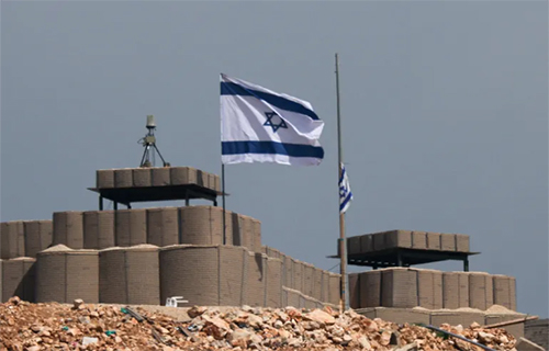
The circulated footage shows an Israeli flag raised above a concrete bunker and an observation post directly overlooking the coast, surrounded by earthen berms and barbed wire. It also documents fortified concrete rooms and elevated observation posts distributed along the coastal strip, reflecting an organized defensive deployment inside the site.
Other parts of the footage show a wide asphalt-paved yard surrounded by high earthen berms equipped with stone steps leading to guard positions, as well as a lower entrance extending into the berm. Tall communications towers, service buildings, concrete walls separating sections of the site and a parking area containing several military vehicles are also visible.
A comparison of satellite images taken on July 15 and July 25 confirms a noticeable expansion in soil-clearing operations and the paving of roads and yards compared with an earlier review conducted by the open-source unit.
The images also show the addition of a new earthen extension alongside the berm, with paving work continuing on the road parallel to the border fence in Rafah, where engineering vehicles were documented operating inside the site.
These findings are consistent with the field footage, which showed infrastructure details that are difficult to identify through satellite imagery alone, strengthening the accuracy of the combined reading of the two visual sources.
An earlier review by the unit had revealed the initial construction of the site. Images taken on June 2 showed work beginning on the ruins of the Swedish Village, covering an estimated area of about 110 meters in length and 85 meters in width.
In early July, work began on an earthen berm that gradually expanded over the following weeks. The images documented a winding berm extending through open and agricultural land in Mawasi Rafah, reaching about 2,650 meters in length by mid-month, beyond the line visible in the images and approaching displaced people’s encampments.
The timeline comparison between the field footage and satellite images shows that, in less than two months, the site underwent a clear transformation from a limited construction point into an integrated military position with concrete fortifications, earthen berms, paved roads, vehicle staging areas and communications towers.
The development comes as part of a field expansion that strengthens Israeli control over the southern coastal strip of the Gaza Strip.