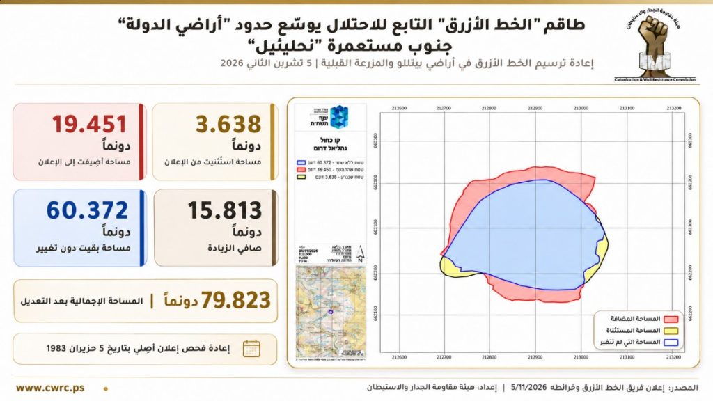
Ramallah (Palestine Foundation Information Center), The Wall and Settlement Resistance Commission has revealed that the Israeli occupation authorities have issued a new notice to expand the southern boundaries of the illegal Nahli’el settlement, built on Palestinian-owned land northwest of Ramallah and al-Bireh governorate. The move will add approximately 15,800 kanals of land to the area classified under this designation, following a review of the boundaries of a previous declaration issued in 1983.
In a statement, the commission said that the new declaration, issued on Thursday, covers lands belonging to the towns of Beitillu and al-Mazra’a al-Qibliya. It adds 19,451 kanals to the boundaries of the previous declaration, while 3,638 kanals have been excluded, resulting in a net increase of 15,813 kanals. The total area covered by the new designation has consequently reached 79,823 kanals.The commission explained that the declaration, issued by the so-called “Custodian of Government and Absentee Property,” is based on the work of the “Blue Line Team,” which is authorized to review and mark the boundaries of lands previously designated by the occupation authorities as “state land.”According to the official map attached to the declaration, the designated area comprises 60,372 kanals within the previous boundaries, 19,451 newly added kanals, and 3,638 kanals that have been excluded.Expansion of settlements around the Talmon bloc
The commission said the significance of the new declaration stems from the location of the targeted lands around the Nahli’el settlement, which lies within the expansion of the so-called Talmon settlement bloc. The bloc includes the settlements of Nahli’el, Neria, and Kerem Reim and is connected to areas extending towards the Talmon and Dolev settlements.It pointed out that expanding the scope of lands under the occupation authorities’ control in this area will provide additional land reserves that could be used for future settlement expansion or related purposes. This will further intensify pressure on Palestinian agricultural land and deepen the geographical fragmentation of villages northwest of Ramallah.The commission added that the move is part of a broader policy aimed at establishing geographical links between illegal settlements and outposts while restricting the space available for Palestinian urban and agricultural development.Continued land seizures northwest of Ramallah
The Wall and Settlement Resistance Commission noted that the new declaration comes just days after another announcement concerning the same geographical area, which the commission documented on November 3, 2026. That declaration covered 2,536.44 kanals of land belonging to the towns of Beitillu, al-Mazra’a al-Qibliya, and Deir Ammar.The commission stressed that the timing of the two declarations reflects an acceleration in the occupation authorities’ efforts to seize land northwest of Ramallah, whether through new declarations designating Palestinian land as “state property” or through the review, demarcation, and expansion of boundaries established under previous declarations.It emphasized that these measures are part of a systematic and ongoing policy aimed at altering Palestinian geography, facilitating the expansion of illegal settlements, and undermining geographical connectivity between Palestinian villages and communities.The commission called for legal and human rights monitoring of the declarations and their accompanying maps, as well as documentation of residents’ rights to the targeted lands, in order to counter attempts to impose new facts on the ground.